
Guest reading progress stays in this browser and is not synchronized to your account automatically. Use the learning panel to include browser marks and save them explicitly. Clearing site data removes browser marks.
Your learning notebook
Save courses and review situations deliberately. Load your account records on another device when you want to continue.
Bookmarks and review choices stay in this browser until you load and save an account. Answers and time spent reading are not recorded.
Saved courses
Saved situations to revisit
Find your marked situations by title or topic, then open the original question and explanation.
Your review choices will appear here when this learning view is ready. Use the account controls above to load account choices.
No situations are marked for review in this learning view.
No saved situation matches these filters. Clear the search or choose all topics.
Identification practice
Land access practice
Field decisions practice
Harvest care practice
Useful reading before this lesson
Start with these guides for background and preparation. You can open any guide at any time.
Brief the outing · Gray Partridge
A short visit along a permitted field margin, with neighbouring parcels and roadside boundaries kept explicit.
An original planning summary to use with the full lesson. Check current law, permission, identification and local conditions separately; this card does not establish readiness or eligibility.
Open the briefing and field checks
Three tools and their jobs
- Parcel-edge sketch: distinguish the permission boundary from a convenient track.
- Binoculars: compare bird features and avoid guessing from a rising group.
- Notebook: keep a single observation separate from any estimate of the whole group.
Rehearse the complete visit
- Before leaving: Mark the usable margin, turning point and adjacent land that has not been authorised.
- On arrival: At the entrance, check crop work, gates and the exact side of the boundary you may use.
- Brief and organise: Walk only the agreed margin and pause before direction changes so the party remains together.
- Return and review: Return without following birds onto unchecked land; record what portion of a group was visible and what was obscured.
Two avoidable mistakes
- A bird crossing a boundary does not extend permission.
- Adding two brief views can double-count the same group.
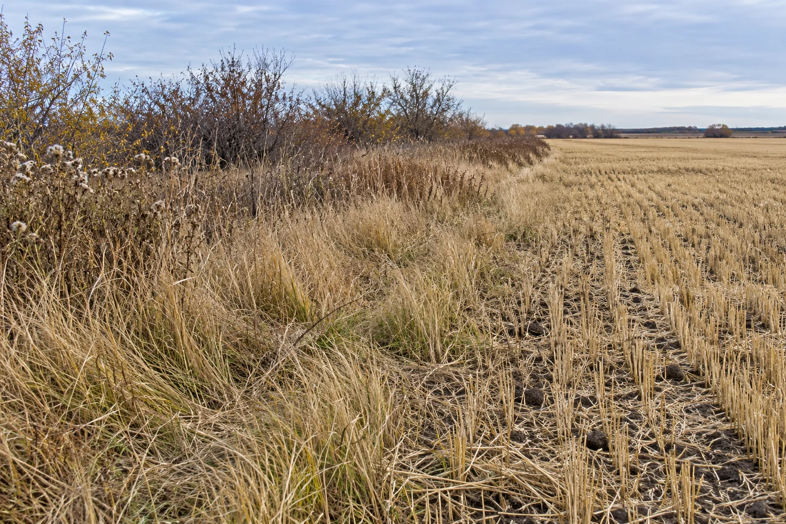
Illustrative habitat, not a real parcel, bird sighting or identification photograph.
Image credit: SKHunter · original AI-generated photo-style teaching sceneWhat you will learn
- Connect current covey observations with food, grass strips and shelter instead of walking every boundary blindly.
- Build a short permitted route that preserves visibility, communication and a realistic recovery plan.
- Recognize a low, uncertain or unsafe opportunity early and pause the group without chasing the covey.
An original SKHunter learning guide
Read a margin as a connected habitat
Gray Partridge use agricultural fields and grassland, including margins with hedgerows or other cover. A covey is a social group, not a guarantee of a particular number of birds. On your map, connect a recently used feeding area with nearby grass or shelter, then compare that hypothesis with what you can actually see from a permitted observation point.
Give each proposed strip a reason for being on the route: fresh sightings, a useful cover change, a sheltered edge or ground that can be searched responsibly. A fence is a boundary to verify, not evidence of public access. Keep roads, farmyards, livestock, posted exclusions and land beyond permission out of the working route, even when the cover looks promising.
A walking plan needs stop points, not just arrows
Choose a manageable first section with a clear start, a visible regroup landmark and an exit. Where ground and permission allow, walking into or across the local wind can help a trained dog investigate scent; a forecast arrow does not describe every sheltered strip. Without a dog, use a shorter route through cover you can see and search, moving steadily with deliberate observation pauses.
For a small group, agree one common front and a pace set by the slowest participant. Nobody slips ahead around the far end of a strip while others continue. Stop before a bend, ditch, fence or cover change hides a person or dog; arrange the next section together. This lesson does not prescribe a spacing, a shooting sector or a universal safe distance.
Manage a covey rise as an identification and recovery decision
A covey can rise suddenly and fly low. Rusty colour or several birds moving together is not sufficient identification of an individual. Study the official species resources beforehand, then leave low, uncertain, screened or unsafe opportunities alone. A bird travelling over a road, toward another person or across an unverified background does not become acceptable because it was encountered on a permitted parcel.
Before starting, decide who observes a possible fall and who coordinates recovery. Stop the group, mark the last certain point against a fixed landmark and keep an observer there while a controlled search is organized. If birds leave the authorized area, do not pursue them across the boundary. Record the observation and leave the covey undisturbed rather than repeatedly forcing it around the same field.
Intermediate fieldcraftAfter permission · walking grassland and field margins
Use this workflow after eligibility, current Gray Partridge requirements and parcel permission have been checked. It covers walking dry, authorized field margins and nearby grass cover, not road hunting, drives toward waiting hunters or a waterfowl decoy setup. Choose the size of the outing from the ground, visibility and recovery means available today.
Read the habitat photograph as clues
- Crop edge: distinguish an actual harvested margin from standing crops or a road verge.
- Grass and weeds: look for usable cover next to the feeding area; avoid assuming every straight edge holds a covey.
- Shrub line: check sightlines, fences and ownership before choosing a short route.
Illustrative habitat, not a real parcel, bird sighting or identification photograph.
Choose a workable kit
| Item | Priority | What it does | Practical choice / alternative |
|---|---|---|---|
| Permission record and offline route map | Core kit | Mark the actual margin, entry, parking, excluded areas, boundaries, regroup points and permitted recovery ground. | A printed map and contact note work without reception. Confirm uncertain fence ownership before making it part of a route. |
| Current licence, rules and required records | Core kit | Carry the applicable documents and a way to record harvest, including a registered ledger where required for your licence and residency. | Check the current Gray Partridge row, district and daily, possession or season conditions before travel; do not borrow the Ducks limit. |
| Binoculars, secured wind ribbon and notebook | Core kit | Observe habitat use without pushing the covey, compare local wind and log sightings with uncertainty. | Use equipment already owned; a tied ribbon and pencil can be more dependable than another app. Remove all temporary markers. |
| Visible outer clothing and suitable footwear | Core kit | Help companions keep track of you and support walking through stubble and uneven grass. | Check current clothing requirements separately. Choose visibility and weather suitability rather than assuming camouflage is essential. |
| Practised hunting kit and personal protection | Core kit | Use equipment suited to your training and the outing, including appropriate eye and hearing protection. | Resolve handling or equipment uncertainty with a qualified instructor before travel. This lesson gives no ammunition recipe or firing-distance rule. |
| Water, weather layers, communications and first aid | Core kit | Allow for slow searching, wind exposure, fatigue, poor reception and a delayed return. | Carry a backup navigation plan and protect a dry layer; shorten the route if the group cannot manage the conditions. |
| Trained dog with an identified handler | Optional | Assist locating and recovery while remaining under reliable control and within the authorized area. | Without a suitable dog, choose shorter, visible cover with a workable human search. A tracking collar supports, but does not replace, control. |
| Dog water, lead and suitable care kit | Optional | Support rest, controlled transitions and checks for feet, seeds, burrs, cuts or fatigue when a dog joins. | Agree the dog’s needs with the handler or veterinarian beforehand. Leave an unfit or untrained dog out of this outing. |
| Recovery, cooling and cleanup supplies | Core kit | Keep lawful recovery, clean bird handling, appropriate cooling and removal of litter practical. | Select cover that can actually be searched. Follow current identification, recordkeeping and transport requirements rather than applying waterfowl instructions automatically. |
Read the cover, boundary and walking line
Original teaching sketch · not to scale. Circles represent people, not safe firing positions. No distance, shooting sector or permission is established by this drawing.
- For Gray Partridge, inspect the grass margin beside a harvested field. This invented scene does not locate a covey.
- A and B show two walkers on the same straight front, not a prescribed spacing or safe shooting zone.
- A possible checked walking loop inside the permitted land. Pause and regroup before a turn or obstacle.
- The boundary is a stop-and-check point. Neighbouring land is outside this example’s permission.
- The original sketch links a harvested field, grass cover, wind, a common walking front and a stop landmark. It is not a measured hunting or firing plan.
- The route stays on authorized ground. A fence, road verge or attractive strip does not establish permission to walk or recover there.
- People and any dog must remain accounted for; stop before a bend or cover change makes the illustrated common front impossible.
- A short no-dog route through visible, recoverable cover is a valid choice. The diagram never guarantees birds, a safe opportunity or access beyond its boundary.
Nine stages of a controlled walking outing
Check the entry and today’s restrictions
Confirm that the permitted margin and its access remain available.
- Locate machinery, workers, livestock, other visitors, roads and any newly posted exclusion before the group leaves the entry.
- Confirm the permitted side of each fence and any permission needed for likely recovery ground.
- Set a return time that includes searching, bird care and a final equipment check, not only walking.
Observe the food-and-cover connection
Choose a first section from current evidence rather than the longest fence.
- Look for recent covey use and the connection between harvested ground, seed-bearing vegetation and shelter.
- Record the observation point, time and uncertainty; tracks or moving grass alone do not identify the species.
- Observe without using a vehicle or dog to move birds into a preferred place.
Draw a short route and a clear exit
Mark a visible stopping landmark before entering the strip.
- Check the wind at walking height and compare it with the route, cover and permission boundary.
- Keep ditches, wire, water, ice, roads and buildings out of an improvised shortcut; plan authorized crossings separately.
- Reject a section if the likely recovery ground is inaccessible, hazardous or too dense for the actual search team.
Agree the common front and stop signal
Let everyone explain the first section before moving together.
- Name the coordinator and dog handler, agree an audible stop signal and choose a pace everyone can maintain.
- Keep companions mutually visible and on the same agreed front; never send someone ahead to block birds.
- If vegetation, a bend or weather hides anyone, stop first and regroup using the safe procedure from hunter education.
Work the margin deliberately
Make a controlled first pass with pauses to observe rather than racing the cover.
- Use changes in vegetation and ground as observation points, checking the whole group before each new section.
- With a trained dog, let the handler manage the search relative to the wind and recall it before boundaries or hazards.
- Without a dog, shorten the section and choose searchable ground; slow observation is more useful than widening beyond communication.
Let uncertainty end an opportunity
Treat a sudden covey rise as a fresh decision, not an instruction to act.
- Identify the individual and the actual background; a flock shape or species name on a map is not enough.
- Leave low-flying, screened or uncertain birds alone, especially when a person or dog could be hidden ahead.
- Do not turn, run or cross the agreed front after departing birds; stop if anyone’s position is uncertain.
Organize recovery before continuing
Pause the whole group and preserve the last certain observation.
- Use a fixed landmark and a stationary observer to retain the possible fall location while the search is organized.
- Let one coordinator manage the search and dog; avoid several people wandering independently through the same cover.
- Stay within permission and safe ground. Resolve any additional access with the responsible owner or manager rather than crossing first.
Adjust one part of the next section
Use the last section’s evidence to change the route without chasing the same covey.
- If birds left early, note the wind, cover and disturbance; do not assume one observation proves the cause.
- If the front broke or a dog ranged beyond control, stop and shorten the route rather than pushing on faster.
- Choose a different verified strip or end the encounter when continued walking would repeatedly disturb the same birds.
Care for birds, the dog and the site
Finish recovery and records before the final departure.
- Complete applicable harvest records promptly and follow current species-identification, handling and transport requirements.
- Use clean handling and suitable cooling; inspect the dog with its handler and provide rest and water as needed.
- Collect cases and litter, remove markers, restore agreed gates and record the habitat, wind and one useful lesson.
Diagnose the walk before adding distance
Pause → check the cause → change one thing
When the walking line breaks, pause together
Compare positions, not shooting angles. Both people stop when one moves ahead or disappears from view. A new shared front is agreed only after contact and the route have been checked.
Line breaks · everyone stops
A has moved ahead of B. Both stop; locate each other and any dog before deciding how to regroup. Do not keep advancing through cover.
Regroup · agree before restarting
While the activity remains paused, regroup at an agreed clear place. Check contact, the route and the boundary; confirm a shared front before starting again.
Orange highlights a reason to stop. The dashed shared line is a communication reference, not a shooting sector or fixed spacing.
This example concerns walking coordination. Actual terrain, visibility, people, dogs and boundaries decide whether the outing can continue. Original teaching sketch · not to scale. Circles represent people, not safe firing positions. No distance, shooting sector or permission is established by this drawing.
| What you observe | Check first | Make one change |
|---|---|---|
| A long margin produces no current sightings. | Does the strip connect food and shelter, or are you following a boundary with no evidence? | Pause and select a shorter verified habitat connection instead of extending the same walk automatically. |
| Coveys leave well ahead of the group. | Consider visibility, local wind, disturbance and dog control without assuming one cause. | For the next distinct permitted section, reduce unnecessary disturbance and change only the clearest relevant factor; do not repeatedly pursue the same covey. |
| A walker or dog disappears behind cover. | Can every participant confirm the actual positions and the agreed front? | Stop immediately, account for everyone and regroup before choosing a shorter visible section. |
| Birds move low toward a road or permission edge. | Identification, background and lawful recovery may no longer be workable. | Leave that opportunity alone and end the approach; a boundary is not something to beat the birds to. |
| Recovery, fatigue or weather is becoming difficult. | Is the original route still supportable by this group and dog today? | Complete the current recovery responsibly, use the planned exit and shorten or end the outing. |
Open the field reference card
- Check the entry and today’s restrictions
- Observe the food-and-cover connection
- Draw a short route and a clear exit
- Agree the common front and stop signal
- Work the margin deliberately
- Let uncertainty end an opportunity
- Organize recovery before continuing
- Adjust one part of the next section
- Care for birds, the dog and the site
Before the next outing
Save one map note connecting the habitat, local wind, visibility and recovery ground. Record where the group stopped and what you would shorten next time; avoid publishing another person’s private access details.
Worked example: the grass strip curves out of sight
Two eligible participants have permission for a harvested field and its grass margin. A trained dog works with one handler. The margin bends behind a shelterbelt, the handler slows, and the other walker begins to disappear around the bend. This is an original planning exercise, not a map of a real property.
Put it into practice
- Call the agreed stop immediately; confirm both people and the dog before anyone continues.
- Use the last mutually visible landmark as the regroup point, following the safe pause procedure learned in hunter education.
- Review the wind, permission edge and cover beyond the bend; shorten the next section so the common front remains visible.
- Resume only when everyone understands the revised route, or leave that strip and use the agreed exit if visibility cannot be maintained.
Turn a sighting into a useful note
A 36-second photographic motion explainer with gentle camera movement, four clear chapters and large on-screen words. Silent; optional captions and a transcript are available.
Choose a section or use the player controls. A text transcript is available below.
Read the video transcript
- 0:00
Describe what you actually saw — Record shape, markings and behaviour before assigning a species name.
- 0:09
Record the observation context — Add the date, viewpoint, light and approximate distance.
- 0:18
Keep uncertainty visible — A single track or a brief glimpse may remain unidentified.
- 0:27
Revisit without assuming — One sighting is not a population estimate or a promise for next time.
Common mistakes to avoid
Turning a fence line into a continuous entitlement
A promising strip may cross ownership, a road allowance or an excluded farm area. Verify the actual access and recovery permissions at each break, rather than following the vegetation indefinitely.
Trying to keep up with every covey movement
Running after a rise separates the group and increases disturbance. Keep the agreed front, record where the birds went and end that encounter when permission or conditions no longer support it.
Using a dog to compensate for an unrecoverable route
A trained dog can assist a sound plan; it cannot authorize entry into another property, make a road safe or remove hidden hazards. Shorten or reject the route before starting.
A partner disappears around a bend while the dog and handler remain behind. What is the right next step?
- Continue along the margin so nobody loses time.
- Stop the whole group, confirm every person and the dog, and regroup before agreeing a visible next section.
- Spread farther apart and rely on the phone to show everyone’s exact position.
Show the answer and explanation
Answer: B. Stop the whole group, confirm every person and the dog, and regroup before agreeing a visible next section.
Losing sight of a participant invalidates the shared walking plan. A coordinated stop and a revised section restore communication; a phone location is not a substitute for knowing the actual positions.
Upland observations: checked margin versus hidden cover
A fictional group records what it can actually inspect. These are general observation notes, not claims about the behaviour of Sharp-tailed Grouse, Gray Partridge, Ruffed Grouse or Ring-necked Pheasant.
Fictional teaching example, not a parcel sighting or current conditions report. Example times are not hunting-hour guidance.
Scroll across the table to compare each observation with its interpretation and next check.
| Time | Direct observation | Count and scope | Interpretation / uncertainty | Next check |
|---|---|---|---|---|
| A visible margin is watched for five minutes; no birds are observed. | 0Zero in this sample Zero birds observed in the checked view. | This is a zero for that view and interval, not proof about nearby cover. | Keep the viewed margin and observation interval with the zero. | |
| Dense cover beside the margin is neither visible through nor searched. | Unknown Cover not inspected; count unknown. | The group has no numerical observation for this cover. It cannot be entered as zero. | Keep it unobserved; choose only a short segment with a checked return and workable visibility. | |
| Two birds are briefly visible, but the details do not confirm species. | 2Observed count Two visible birds; species unconfirmed. | The count and uncertain identification are different fields. Habitat or the course title cannot supply the missing identity. | Record the last-seen landmark and uncertainty without filling in a species guess. |
Counts belong to the stated view or sample. Repeated views may include the same animals; these rows are not summed into a unique population total.
A concrete next action
Keep the route question small: what can the group observe and return from today? Do not extend a walk just to turn unknown cover into a more reassuring record.
Pause and reflect
Which rows can carry a number, and which must stay unknown?
Read the reasoning
The first row carries zero for a checked view; the last carries two visible birds with uncertain species. The uninspected cover has an unknown count. These entries are not a population estimate.
Terms on this page
Open a term for its meaning, a common mix-up and the existing guide. English terms and acronyms are retained.
direct observation
What was actually seen, heard or measured, with the view and context recorded.
Common mix-up: A sound can be observed without confirming an animal’s identity or number.
inference
An explanation or estimate drawn from observations, rather than another separately observed fact.
Common mix-up: A confident file name, habitat label or repeated copy does not add a new observation.
sample coverage
The view or ground, and observation interval, that were actually checked for a particular record.
Common mix-up: Hidden or uninspected ground lies outside that checked sample, even when it is nearby.
Current checks and official context
Use the upland species row and your own licence category
Sharp-tailed Grouse and Gray Partridge are upland game birds. Read the current provincial species table and licence conditions for your residency, place and date. Check the applicable Game Bird Licence, Wildlife Habitat Certificate, education and youth requirements; these two upland species use provincial requirements. If the outing also targets migratory birds, check the additional federal requirements for that activity.
Check daily, possession and any season limits, and whether your licence category requires a registered harvest ledger, entries at harvest and a harvest survey. Canadian-resident and non-resident terms can differ from Saskatchewan-resident terms. The latest online guide and updates take precedence over a remembered season; these lessons do not declare that hunting is open today.
Check the whole walking route, not just the starting point
Confirm the exact parcel, authorized people, activity, dates, dog conditions and approach with the owner, occupant or responsible manager. Grass strips, fences and hedgerows may border a different parcel. Stop before the boundary; a bird or a dog crossing it does not extend your permission.
Hunters Extras includes named game-bird closures, including specified water areas and applicable 500 m restrictions. An upland walk on dry land can still enter a restricted area. Check the current named-area list, dates, feeding-station or lure-crop conditions, local closures and posted instructions; there is no blanket 500 m rule for every pond.
Check equipment, recovery and transport requirements separately
Confirm current lawful equipment and ammunition conditions for the species and exact property. Do not copy the waterfowl rules into an upland-only trip, or assume lead shot is allowed on every site. Keep people, dogs, livestock and the background accounted for; uncertain identification, low or obscured flight, lost contact or an unrecoverable fall are reasons to pass and reassess.
Prepare prompt lawful recovery, suitable cooling and clean handling before starting. Follow current provincial identification, possession, transfer and transport instructions; check destination and border requirements separately. Consult current avian-influenza advice, avoid sick or dead birds found in the field and prevent dogs from contacting them. The sketches illustrate coordination, not certified safe shooting positions.
Pocket lesson card
Public teaching summary for review and offline reading. It contains no actual trip records, permissions, parcel conditions or coordinates. Use the full lesson and current official guidance for your own plan.
Save the HTML for offline text. Use your browser’s Print menu to print the opened card; online links require a connection.
Read the pocket card
Gray Partridge · field preparation
Before leaving
- Mark the authorized margin and the permitted side of each fence.
- Agree any suitable dog’s handler and care plan, or a workable alternative.
At the location
- Use short visible segments and recognizable last-seen landmarks.
- Observe food-and-cover connections without supplying a species guess.
Return
- Close the return check-in and collect equipment and waste.
- Recheck people, any dog and temporary markers at the regroup point.
Review
- Choose one missing piece of evidence to check next time.
- Keep the number seen separate from uncertain species identity.
A fictional observation example
Fictional example: two birds are briefly seen, but species is unconfirmed. Keep a count of two and an unknown species as separate fields.
Full reviewed lesson · onlineSource lesson editorial review: 2026-11-01
Turn this lesson into your next outing
Review the date, species, starting template and linked day plan in an editable preparation draft. You choose what to add and save.
Prepare your own trip
Review a preparation draftContinue learning
Game birds after the harvest: clean handling, cooling and the journey homeTry a practical situation
Open related practiceOpening a draft does not create a saved checklist. A checked item records your own review, not permission or an open season.
Scenario practice
Put your field decisions into practice.
Try 24 situations across identification, access, field adjustments and harvest care. Compare your choice with the explanation, then revisit the relevant lesson.
Original sources
- Government of Saskatchewan · Hunting in Saskatchewan and current Hunters Guide
- Government of Saskatchewan · Hunting Licences
- Government of Saskatchewan · Hunters Extras
- Government of Saskatchewan · avian influenza in wild birds
- Cornell Lab of Ornithology · Gray Partridge life history
- Cornell Lab of Ornithology · Gray Partridge identification
- Washington Department of Fish and Wildlife · Gray Partridge habitat and behaviour
- Texas Parks and Wildlife Department · Hunter education: hunting with dogs
- North Dakota Game and Fish · Game identification: Gray Partridge
Use this as a planning guide. Check current official requirements and site conditions before travelling.
Help improve this guide
Tell the editor about something on this public page that needs attention.