
Guest reading progress stays in this browser and is not synchronized to your account automatically. Use the learning panel to include browser marks and save them explicitly. Clearing site data removes browser marks.
Your learning notebook
Save courses and review situations deliberately. Load your account records on another device when you want to continue.
Bookmarks and review choices stay in this browser until you load and save an account. Answers and time spent reading are not recorded.
Saved courses
Saved situations to revisit
Find your marked situations by title or topic, then open the original question and explanation.
Your review choices will appear here when this learning view is ready. Use the account controls above to load account choices.
No situations are marked for review in this learning view.
No saved situation matches these filters. Clear the search or choose all topics.
Identification practice
Land access practice
Field decisions practice
Harvest care practice
Useful reading before this lesson
Start with these guides for background and preparation. You can open any guide at any time.
First Deer observation visit: make a note another person can read ↓
Brief the outing · White-tailed Deer
Observation of a woodland–field transition from a verified point, with no inferred animal corridor treated as a fact.
An original planning summary to use with the full lesson. Check current law, permission, identification and local conditions separately; this card does not establish readiness or eligibility.
Open the briefing and field checks
Three tools and their jobs
- Binoculars: inspect the visible edge without entering concealed ground.
- Dated field sketch: separate viewpoint, visible ground and blocked corners.
- Return and receiving plan: connect the observation outing to any later lawful recovery and transport.
Rehearse the complete visit
- Before leaving: Choose an authorised observation point and a return time; note which part of the edge the position can actually show.
- On arrival: Compare crops, visibility and human activity with the previous note before settling into observation.
- Brief and organise: Record start/end times and visible features; an empty interval or obscured corner remains a limited observation.
- Return and review: Return on the checked route and decide what evidence a second visit should test instead of declaring a route confirmed.
Two avoidable mistakes
- One track or one animal view does not establish a regular movement corridor.
- A field map can imply visibility that vegetation blocks on the ground.
First Deer observation visit: make a note another person can read
A useful first visit can answer one small question: what is actually visible from an agreed stopping point? Rowan and Casey rehearse that question on a fictional parcel. They keep their own position, an animal observation and a mapped feature as separate entries.
Original daylight observation exercise. Practise at home first, then on a short route whose access is already confirmed, without firearms or ammunition. It does not establish a species identification, hunting opportunity or permission for a different place.
Build one traceable observation
- Mark the station
Name your stopping point and the map used.
- Describe the view
Separate the checked view from hidden ground.
- Label the evidence
Keep direct observation and interpretation apart.
- Choose the follow-up
Write one question for the next lawful visit.
Focus this table and use the arrow keys to read the four columns independently.
| Entry | What Rowan records | What it supports | What remains unknown |
|---|---|---|---|
| Station A | My saved position, beside the agreed stopping point. | Where the observer stood. | It is not an animal coordinate or a verified parcel boundary. |
| Field corner | Corner visible; ground behind the hedge hidden. | The limits of this viewing period. | Whether an animal was behind the hedge. |
| Brief animal view | A deer-shaped animal crossed the visible gap; features unclear. | An observation to retain with its uncertainty. | Species, licence category and where it went after the view ended. |
| Photographed mark | Photo, observation date, surface and a separate interpretation. | What was visible when the photograph was made. | Who made the mark or exactly when it was made. |
Rehearse the note before the real visit
- On a printed map or offline view, mark the agreed station, checked return and permission boundary separately. Have Casey point to each. Choose a viewing question small enough to answer without adding an unplanned move.
- At the lawful daylight stop, use binoculars to observe. Never use a firearm sight as a spotting tool. Write the observation time, visible sector and obstruction. If a feature is unclear, keep the uncertainty instead of supplying it from a reference picture.
- Back at the table, ask Casey to retell only what the note supports. Preserve the original entry when adding a correction. If the plan needs another view, arrange a separate visit with its own access and return checks.
Three notes to repair
The phone saved a point. Was the deer standing there?
Rowan saved a position while standing at Station A. Later the notebook calls it “deer location”. That label has changed the meaning of the evidence: the saved point describes the observer, while the animal was seen elsewhere.
Keep the original point and relabel it as the station. Describe the animal’s observed position separately using the visible landmarks, and retain any uncertainty. Do not invent a precise coordinate to make the map look complete.
An old photograph returns. Is it evidence of today’s activity?
The shared photograph shows a mark, but its original date and exact position are missing. Calling it “fresh sign today” supplies information the photograph does not contain. Another crop of that image is still the same observation.
Keep it as an unresolved reference and ask for the original context. For a new observation, record its own date, surface and location description. Keep the visible mark separate from guesses about species, number or the age of the sign.
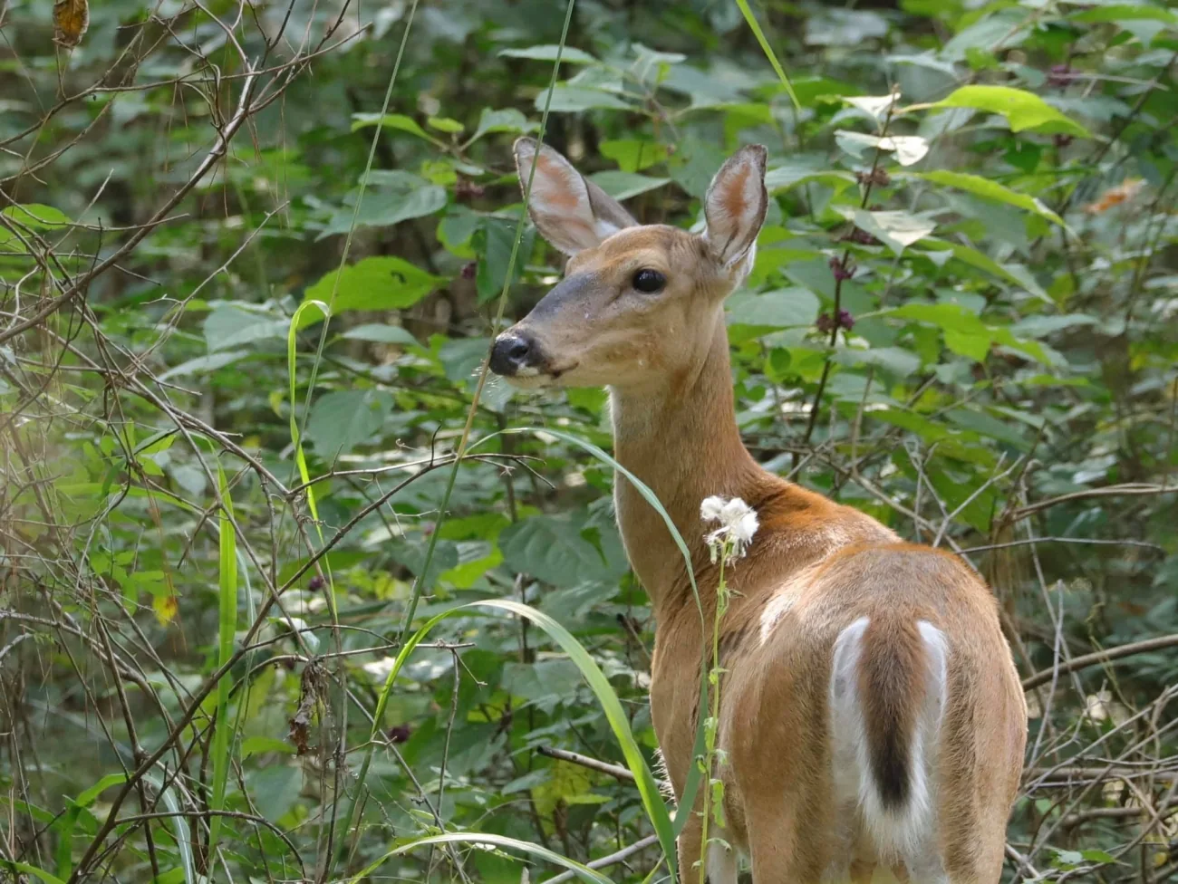
Real species reference photograph from the credited source. This is one view of an individual, not a local sighting or evidence of current animal numbers. Use the lesson to connect observations with a checked field plan.
Image credit: Regina Snow/USFWS · Public Domain · View image sourceWhat you will learn
- Read a field-and-cover mosaic without treating habitat as a sighting.
- Keep observation stations, animal positions and signs as distinct evidence.
- Choose a route that the group can complete with its return and retrieval capacity.
An original SKHunter learning guide
Read the cover–field transition from a checked viewpoint
Use a small observation plan that keeps a known return separate from questions about animal movement.
Conceptual sketch · no scale, coordinates, parcel boundaries or suggested destination. The walking route is assumed checked for this example; every real approach needs its own access and ground checks.
Read the sketch
- A · checked observation point
- R · return / meeting point
- Dashed green line · checked walking route
- Hatched area · not checked; outside this plan
Habitat shapes: Dark green: woody cover. Pale gold: open field. These shapes only organise the example.
What is actually observed
From A, the near edge is visible and the far corner is hidden by cover.
What still needs evidence
The edge might connect resources. This sketch contains no sighting and does not establish animal presence or a route.
Work through the example
- 01
Choose one visible edge
Use A to describe the part of the woodland–field edge you can actually see. Leave obscured ground unfilled.
- 02
Record the whole observation
Write the time, visibility and duration, including a visit without a sighting.
- 03
Separate a possible connection
A connection between cover and open ground is a question to investigate; it is not a confirmed travel route.
- 04
Return and compare visits
Use the checked route to R. Compare dated notes before deciding whether a further visit is useful.
Rehearse your own decision
Describe the evidence first, then decide what needs checking before another visit.
- Can another person identify both A and R from your private plan?
- Which part of the edge was hidden, and did you keep it out of your conclusions?
- What one additional observation would test your explanation?
Sketch resources before drawing a walking route
White-tailed Deer use many landscapes, including fields, woods and river corridors. On your checked parcel, sketch three things separately: open vegetation, thicker cover and the transitions you can actually see. Label a crop or woodland only as mapped until you have observed its present condition. Choose one small question for the visit, such as whether a particular edge is visible from an authorised stopping point. Work on a printed or offline map and mark the permission boundary before adding any possible animal movement.
- Mark the observation point, parking and return separately.
- Label the date and which features came from a map.
- Keep an unconfirmed crossing as a question, not a route.
Build a repeatable observation station
Use binoculars from a stable place where the group can stop safely. Divide the view using real landmarks: near field margin, distant corner, brush gap. Scan each part slowly, then revisit vegetation that initially looked empty. Record which ground folds and branches hide the view. If an animal appears, follow the same individual long enough to describe visible features; keep its approximate location separate from your own GPS point. A second visit is easier to compare when you retain the station, viewing period and areas you could not inspect.
- Observe with binoculars; never use a firearm sight as a spotting tool.
- Record species uncertainty when tail or other useful features are hidden.
Use wind and visibility as observations
Before moving, note the wind you can feel at the station and whether it changes along the sheltered edge. Add the effect on your own trip: exposed waiting may be colder, foliage may obscure motion, and gusts may mask ordinary sounds. Do not treat an app arrow as a guarantee of conditions in a hollow or a promise that deer will travel one way. Choose the next checked stopping point while everyone can still identify the return. If the view or group communication deteriorates, shorten the observation rather than pressing farther into cover.
Keep a sign ledger instead of a confidence story
Photograph a track, pellet group, rubbed stem or disturbed patch with a scale placed beside it when you can do so without disturbing the feature. Add the surface, recent weather you actually know and the exact observation time. Describe the mark before proposing an explanation. Soft mud can enlarge a print; overlapping tracks can confuse direction. A rubbed stem does not establish that a particular buck is present now. Keep possible species, number, sex and age of the sign as separate uncertainties, then look for independent evidence on later visits.
Decide whether another move answers a useful question
At each stop, compare the remaining question with the disturbance and return cost of another move. A short observation may show that a brush gap is blocked, while walking through every dense patch adds little information. Leave undisturbed cover alone when your plan has no clear reason to enter. Where an animal changes its behaviour because of you, stop advancing and give it space. Record an alternate observation station for a later authorised visit instead of following a disappearing animal across an unchecked line.
Plan the ordinary end before the exciting part
Walk the return in daylight during a preparation visit and check gates, footing and who carries essential supplies. For a hunting outing, discuss a lawful retrieval route, available help, cooling arrangements and current CWD checks before committing to a destination. The route back can be harder with additional equipment or a load. Set a turnaround decision tied to the group and conditions, not an animal sighting. End with a short debrief: one useful observation, one unresolved question and one change to the next plan.
- Recheck species, person, date, WMZ and licence against current official material.
- A sighting, track or old permission note does not expand access.
Case: the visible edge ends at an unchecked corner
From a confirmed station you see a deer briefly enter brush near a fence. Your map pin marks where you stand, and the next corner is outside the route you checked.
Put it into practice
- Record the visible deer features and uncertainty without assigning a hidden tail.
- Save the observer station and the animal’s approximate position separately.
- Keep the unchecked corner outside today’s route; do not follow the deer through it.
- Continue the planned observation or leave by the known return.
- At home, review the boundary and decide what permission or viewpoint question to resolve.
Common mistakes to avoid
Every promising edge needs to be walked
Use a specific observation question; crossing all cover can add disturbance without useful evidence.
One sign tells the whole story
Separate the mark, proposed species and uncertain time; seek independent evidence.
The return is tomorrow’s problem
Choose the destination only after discussing return, retrieval and cooling capacity.
A deer disappears beyond the checked route. What is the useful next step?
- Follow immediately before losing it.
- Record the observation and retain the confirmed boundary and return.
- Move the permission pin to the deer.
Show the answer and explanation
Answer: B. Record the observation and retain the confirmed boundary and return.
A sighting adds an observation. It does not provide permission, a checked approach or a new route.
Deer: two views and a sign are three different records
A fictional observer separates sightings from signs. The example does not identify White-tailed Deer or Mule Deer from a hidden feature or from a track alone.
Fictional teaching example, not a parcel sighting or current conditions report. Example times are not hunting-hour guidance.
Scroll across the table to compare each observation with its interpretation and next check.
| Time | Direct observation | Count and scope | Interpretation / uncertainty | Next check |
|---|---|---|---|---|
| One deer is visible, but the features needed for a species comparison are obscured. | 1Observed count One deer; species unconfirmed. | A visible individual is recorded. The missing features do not justify choosing White-tailed Deer or Mule Deer. | Describe what is actually visible and keep the species field uncertain. | |
| One deer is visible later beyond another landmark; continuity with the earlier view was lost. | 1Observed count One deer in a later view. | It may be a repeat of the earlier individual. Two sighting rows do not prove two unique deer. | Retain both time-stamped views and mark the possible repeat. | |
| A track is photographed at the edge; no animal is seen there. | Unknown Sign record; no animal count established. | The sign does not supply an individual identity, a current animal count or a confirmed age of the sign. | Keep the sign description, scale and location separate from animal-sighting rows. |
Counts belong to the stated view or sample. Repeated views may include the same animals; these rows are not summed into a unique population total.
A concrete next action
Use separate sighting and sign notes. Choose one next check that could resolve the view or route; leave unresolved identity and repeat status visible.
Pause and reflect
Would changing the third row’s count to zero improve the record?
Read the reasoning
No. It is a sign observation without an animal count, not a completed animal-count sample. Keep its count unknown and avoid assigning either deer species from the sign alone.
Terms on this page
Open a term for its meaning, a common mix-up and the existing guide. English terms and acronyms are retained.
observer fix
The recorded position of the observer’s device when its location was saved.
Common mix-up: It locates the observer, not automatically the animal seen across the field.
estimated animal position
An approximate animal location inferred from the view, direction and landmarks, kept separately from the observer fix.
Common mix-up: Moving a phone fix does not preserve its measured status or turn the animal estimate into a measurement.
direct observation
What was actually seen, heard or measured, with the view and context recorded.
Common mix-up: A sound can be observed without confirming an animal’s identity or number.
inference
An explanation or estimate drawn from observations, rather than another separately observed fact.
Common mix-up: A confident file name, habitat label or repeated copy does not add a new observation.
Current checks and official context
Match the current Saskatchewan opportunity
Before a hunting outing, match the actual species, person, licence, WMZ, method and date with current official tables and later updates. The landscape examples do not determine eligibility or an open season.
Keep biology, access and health checks distinct
Out-of-province wildlife references explain biology, not Saskatchewan hunting law. Confirm the whole route and land conditions separately, then review current CWD and handling arrangements for the actual outing.
Pocket lesson card
Public teaching summary for review and offline reading. It contains no actual trip records, permissions, parcel conditions or coordinates. Use the full lesson and current official guidance for your own plan.
Save the HTML for offline text. Use your browser’s Print menu to print the opened card; online links require a connection.
Read the pocket card
White-tailed Deer · field preparation
Before leaving
- Sketch field, cover and permission edge separately from possible movement.
- Choose a repeatable binocular station and viewing sector.
At the location
- Describe visible individual features and retain missing-feature uncertainty.
- Keep tracks and other signs separate from sighting rows.
Return
- Close the return check-in and collect equipment and waste.
- Follow the checked return without adding an unconfirmed crossing.
Review
- Choose one missing piece of evidence to check next time.
- Do not turn two sighting rows into two unique deer.
A fictional observation example
Fictional example: one deer is seen at two times after continuity was lost. Keep one per view; the number of unique individuals remains unresolved.
Full reviewed lesson · onlineSource lesson editorial review: 2026-11-02
Turn this lesson into your next outing
Review the date, species, starting template and linked day plan in an editable preparation draft. You choose what to add and save.
Prepare your own trip
Review a preparation draftContinue learning
White-tailed Deer or Mule Deer: compare the whole animalTry a practical situation
One photograph, two conflicting recordsOpening a draft does not create a saved checklist. A checked item records your own review, not permission or an open season.
Scenario practice
Put your field decisions into practice.
Try 24 situations across identification, access, field adjustments and harvest care. Compare your choice with the explanation, then revisit the relevant lesson.
Original sources
- Connecticut DEEP · White-tailed Deer habitat and identification
- National Park Service · White-tailed Deer and Mule Deer biology
- Government of Saskatchewan · Current Hunters Guide and updates
- Government of Saskatchewan · Hunters Extras, access and ethical hunting
- Government of Saskatchewan · Current CWD testing and sample arrangements
Use this as a planning guide. Check current official requirements and site conditions before travelling.
Help improve this guide
Tell the editor about something on this public page that needs attention.