
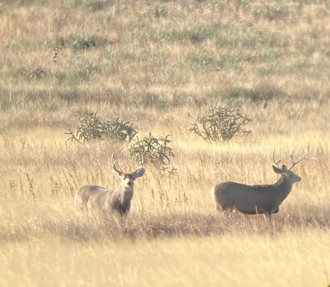
Representative photograph from the credited source, taken outside Saskatchewan. It is not a current sighting, a distribution map or a complete identification guide.
Image credit: Nicholas Pope/USFWS · Public Domain · View image sourceWhat you will learn
- Compare Mule Deer with White-tailed Deer using a full view.
- Separate observation visibility from habitat quality.
- Keep a location estimate and its uncertainty together.
An original SKHunter learning guide
Build a record, not a prediction
Teaching diagram · not a map- 01Observe
Look from a lawful position without moving closer to obtain an answer.
- 02Describe
Record visible features, time, light, distance and behaviour.
- 03Keep uncertainty
Separate what you saw from what you think it might mean.
One clue starts a question. Several consistent observations build a better record; uncertainty remains a valid outcome.
Compare a set of features, not just ears
Large ears are a familiar Mule Deer clue, but the apparent size changes with the viewing angle. Compare the ears with the tail and rump when these are visible. A narrow tail with a dark tip is useful alongside the whole outline; typical antler branching can help when clearly seen but does not cover every animal or age. Practise by describing a reference photograph before reading its caption. In the field, leave any unseen feature blank rather than borrowing it from the textbook animal.
Ask what the viewpoint allows you to see
Open ground can make animals easier to notice than dense vegetation. That difference in visibility is not automatically a difference in animal numbers. When comparing two potential observation sites, write down what each view excludes: a fold in the ground, tall grass, a distant fence or a wooded draw. A landscape photograph from your lawful viewpoint can help explain these blind areas later. Compare repeated visits made under reasonably similar conditions before drawing a stronger conclusion about use of either site.
Keep the animal and the observer on different pins
Your phone position identifies where you stood, not necessarily where the deer stood. If the animal was across a valley, placing its observation on your own position can attach it to the wrong parcel. Save the checked viewpoint accurately, then describe the animal’s position as approximate and include a landmark. Where the parcel or zone boundary is unclear, preserve that uncertainty. Revisit the map and permission record before planning another outing; do not infer a usable route from a straight line to the sighting.
Worked example: two deer beyond a shallow draw
You can see large ears, but vegetation hides both tails. Your map position is on the near side of the draw.
Put it into practice
- Record two deer and the actual visible features, with species still uncertain.
- Save your viewpoint as the observer location; describe the animals relative to the distant landmark.
- Note the hidden ground and the approximate location accuracy.
- Compare an identification reference and inspect parcel boundaries before any future visit.
Turn a sighting into a useful note
A 36-second photographic motion explainer with gentle camera movement, four clear chapters and large on-screen words. Silent; optional captions and a transcript are available.
Choose a section or use the player controls. A text transcript is available below.
Read the video transcript
- 0:00
Describe what you actually saw — Record shape, markings and behaviour before assigning a species name.
- 0:09
Record the observation context — Add the date, viewpoint, light and approximate distance.
- 0:18
Keep uncertainty visible — A single track or a brief glimpse may remain unidentified.
- 0:27
Revisit without assuming — One sighting is not a population estimate or a promise for next time.
Common mistakes to avoid
Ears alone settle the question
Perspective can exaggerate size. Compare multiple features instead of treating one cue as a test.
More sightings means more animals
A clearer sightline can produce more observations even when the underlying use is unknown.
The GPS pin is the animal location
A location measured at your phone belongs to the observer unless you deliberately record another point.
A deer is visible across a valley. What does your phone’s GPS position directly describe?
- The exact animal location.
- The centre of the nearest hunting parcel.
- The place where the phone and observer are.
Show the answer and explanation
Answer: C. The place where the phone and observer are.
Record the viewpoint separately. An animal position across the valley needs its own estimate and an explanation of the uncertainty.
Current checks and official context
At a glance
- Large ears and a black-tipped tail are useful clues.
- Last year’s opportunity may not apply this season.
- A visible deer does not establish permission or an open season.
Habitat clues help plan a scouting visit. They do not establish that animals are present or that hunting is permitted.
Use a complete view where possible
Mule Deer identification uses the large ears, narrow black-tipped tail and other body features together. Antlers alone are not a sufficient field checklist, especially when the view is incomplete. Compare the linked species reference and keep an uncertain observation labelled as uncertain rather than silently treating it as White-tailed Deer.
- Note the combination of visible features.
- Separate identification from sex or age classification.
- Do not treat a track alone as a confirmed animal identification.
Check the land before following a sighting
Open country and brushy cover may provide observation opportunities, but the lawful viewpoint matters first. Inspect the parcel and neighbouring boundaries, obtain required permission and confirm a usable approach. If an animal crosses a boundary, the permission arrangement needs a fresh check; a map observation does not authorise following it.
- Write the exact legal land description in your notes.
- Mark a checked parking or entry point.
- Record observation time and whether animals were merely passing through.
Rebuild the plan from current information
Open Saskatchewan’s current Mule Deer opportunity update and the final Hunters Guide, then match the complete season row to your hunt. Check the licence category, WMZ, method, sex restrictions and later notices together. Review applicable CWD instructions before choosing a sample destination; do not infer a testing exemption from a missing map warning.
- Confirm the year of any saved document.
- Recheck a destination near a WMZ boundary.
- Resolve conflicting information with the responsible ministry.
Turn this lesson into your next outing
Review the date, species, starting template and linked day plan in an editable preparation draft. You choose what to add and save.
Prepare your own trip
Review a preparation draftContinue learning
Mule Deer fieldcraft: read open country without losing the ground between viewpointsTry a practical situation
Open related practiceOpening a draft does not create a saved checklist. A checked item records your own review, not permission or an open season.
Original sources
- U.S. National Park Service · White-tailed Deer and Mule Deer
- Government of Saskatchewan · Current Hunters Guide and updates
- Government of Saskatchewan · 2026–27 hunting opportunities
- Government of Saskatchewan · Current CWD testing instructions
- Arizona Game & Fish Department · Deer comparison
Use this as a planning guide. Check current official requirements and site conditions before travelling.
Help improve this guide
Tell the editor about something on this public page that needs attention.